
Mountains-to-Sea Trail
WaterfallsViewsPeaksHistoryBackcountry campsGapsVisitor centersTunnelsBridges
Along the way Johns River Road Backcountry Campsites Air Bellows Road Bridge Azalea Road Bridge Bamboo Road Bridge Big Witch Bridge County Road Bridge County Road Bridge Docks Gap Bridge Goshen Creek Bridge Goshen Creek Culvert #1 Goshen Creek Culvert #2 Hood Road Bridge and 113 more
Trailheads Balsam Gap MP 443.0 3,340 ft Drive there · Balsam Gap Overlook MP 359.7 5,316 ft Drive there · Basin Cove Overlook 3,301 ft Drive there · Bee Tree Gap at MP 367.6 4,893 ft Drive there · Buck Springs Parking Area MP 407.6 4,998 ft Drive there · Cherry Cove Overlook MP 415.7 4,317 ft Drive there · Craggy Gardens Picnic Area 367.6 5,223 ft Drive there · Craven Gap MP 377.4 3,125 ft Drive there · Double Top Mtn. MP 435.2 5,356 ft Drive there · Folk Art Center MP 382.1 2,250 ft Drive there · Forest Service Road 816 MP 420.1 5,886 ft Drive there · Grassy Ridge Mine Overlook MP 436.9 5,253 ft Drive there · Graybeard Overlook MP 363.4 5,592 ft Drive there · I-26 Overpass MP 391.8 2,269 ft Drive there · Jumping off Rocks Overlook 3,162 ft Drive there · Lick Log Gap MP 435.8 5,144 ft Drive there · Mt Mitchell Parking Area 6,577 ft Drive there · Mt. Mitchell Access Road 5,362 ft Drive there · Mt. Pisgah Parking Area MP 407.6 4,994 ft Drive there · Northwest Trading Post Mp 258.5 3,112 ft Drive there · Ox Creek MP 375.6 3,258 ft Drive there · Singecat Ridge Overlook MP 345.5 3,407 ft Drive there · SR 215 Off Parkway MP 423.2 5,122 ft Drive there · State Highway 16 MP 261.3 3,099 ft Drive there · Stations Inn Off Parkway Mp 248.1 PwR 2,829 ft Drive there · Sweeten Creek Road MP 388.1 2,336 ft Drive there · Trail Crosses Parkway at MP 414.5 4,399 ft Drive there · Trail Crosses Parkway MP 381.3 2,444 ft Drive there · Trail Crosses Parkway MP 384.8 2,122 ft Drive there · Trailhead 4,395 ft Drive there · Trailhead 3,518 ft Drive there · Trailhead 2,203 ft Drive there · Trailhead 5,822 ft Drive there · Trailhead 3,420 ft Drive there · Trailhead 2,549 ft Drive there · Trailhead 4,167 ft Drive there · Trailhead 2,383 ft Drive there · Trailhead 3,737 ft Drive there · US 25 MP 388.9 2,244 ft Drive there
Explore the Middle Prong Wilderness the Park Service's write-up
1-8 Hours · dogs allowed · season <p>The Parkway often closes in the winter because of ice and snow. Check the <a href="https://go.nps.gov/brp-map">road closure map</a> before you head out to make sure you can get to your destination.</p>
Start Rough Butt Bald Overlook (Milepost 425)
"A wilderness, in contrast with those areas where man and his own works dominate the landscape, is hereby recognized as an area where the earth and its community of life are untrammeled by man, where man himself is a visitor who does not remain."
-The Wilderness Act
In 1964, the Wilderness Act was established to give some federal lands the highest level of protection. Meant to preserve the "wildest of the wild," wilderness areas have no roads and no development. They are often the last pieces of pristine wildlands that once stretched across the whole country. Managed to minimize evidence of human presence, trails are not marked with signs or blazes and are often only minimally maintained. Having a map, compass, and the ability to use them are requirements in wilderness. Hiking in wilderness areas often requires a higher level of skills and preparedness than other trails.
Wilderness rules include:
No campfires allowed
Group size must be less than 10
Bicycles are not allowed
The Middle Prong Wilderness Area is nearly 8,000 acres of rugged terrain located within Pisgah National Forest south of Asheville. Designated in 1984, the Middle Prong has the Blue Ridge Parkway for part of its southern and western boundary. This proximity makes the Parkway an excellent jumping off point for wilderness hiking.
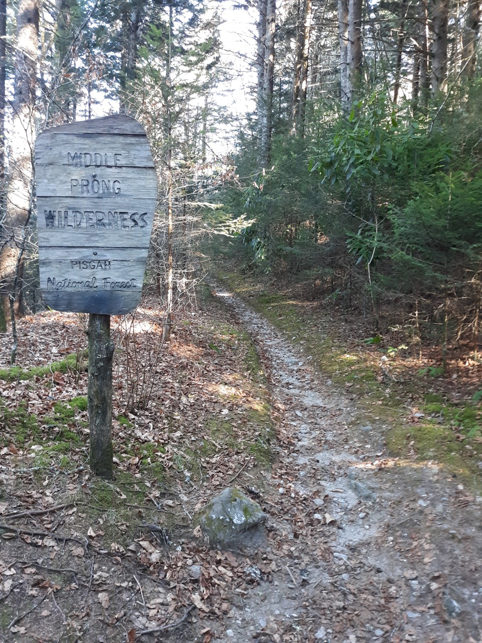
Park at the Rough Butt Bald Overlook at Milepost 425.4. Across the road and slightly south of the overlook there is a trail that enters the forest. This blue-blazed connector trail soon comes to a T-junction with the Mountains-to-Sea Trail (MST). Take a right and head north on the MTS. You will quickly encounter the Middle Prong Wilderness sign marking your entrance into the wilderness area. The MST will continue through the Middle Prong Wilderness for approximately 5 miles until it crosses NC Highway 215. Other trails will branch off the MST to the north and head further into the wilderness area.
Wilderness conjures up different feelings to different people. To some, the idea of being in a wild, undeveloped area where they must depend on their own self-reliance is exhilarating. To others, wilderness can be a scary, inhospitable place that seems entirely inaccessible to them. And, of course, many fall somewhere in between those sentiments. The beauty of the Middle Prong Wilderness is that it can be explored on many different levels. The novice hiker can take a short stroll on the well-established Mountains-to-Sea Trail and get a taste of wilderness travel. An experienced hiker can test their mettle by plotting a longer route into the heart of the Middle Prong.
Either way, it's worth it. This is an exceptionally beautiful place and generally less crowded than other trails in the area. The forest is dense and moist with mosses and ferns draping the trees and ground. Ranging between 5,000 and 6,000 feet in elevation, the Middle Prong Wilderness has Fraser fir and red spruce forest, grassy open meadows, cold mountain streams, and high peak ridges. Some sections of trail are wider and follow an old railroad bed from long ago logging operations.
Are you ready to give wilderness a try?! Be prepared. Do your homework. Expand your comfort zone and challenge yourself. The reward is experiencing a magnificent area that is a hidden gem of the Parkway.
Accessibility The trail from the Rough Butt Bald Overlook is a narrow (2-3 feet wide) dirt path with rocks and exposed roots. It is rated as moderately difficult with some elevation changes and obstacles like small creek crossings. Trails in wilderness areas are not marked, so users must pay close attention and be skilled in map and compass reading.